Skip to content

District · Kota division

Jhalawar News — Latest from Jhalawar

Politics, administration, crime, education, farming and every local story from Jhalawar district (Kota division).

31°CClear · 18°/32°झालावाड़All alerts
KNOWN FORGagron FortOranges

Stories from Jhalawar will appear here soon. Meanwhile, read the latest from Rajasthan.

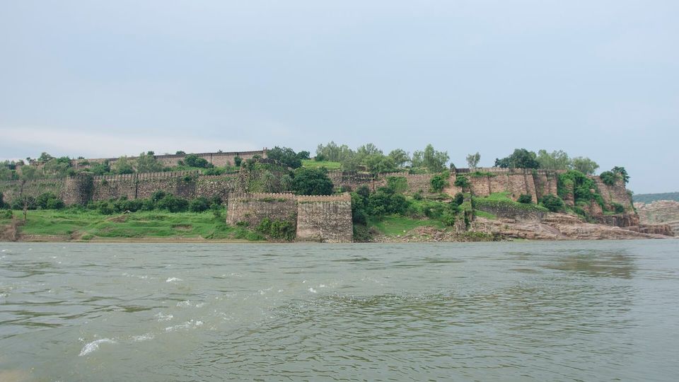
Gagron FortOranges

About Jhalawar

Jhalawar district is one of the 50 districts of Rajasthan, with its administrative headquarters in the historical city of Jhalawar. It lies in the Hadoti region on the edge of the Malwa Plateau and is classified among India’s most backward districts receiving special development funds.

Overview

Jhalawar district is one of the fifty districts of Rajasthan, situated in western India. It occupies an area of 6,219 square kilometres and forms part of the Kota division. The district’s administrative headquarters is the historical city of Jhalawar, which also serves as the municipal council for the region.

Geographically, Jhalawar district is bounded by several other districts: to the northwest it borders Kota district, to the northeast Baran district, while its eastern, southern and western frontiers meet districts of the neighbouring state of Madhya Pradesh – Guna district to the east, Rajgarh and Agar Malwa districts to the south, and Ratlam and Mandsaur districts to the west.

The city of Jhalawar lies in the southeastern part of Rajasthan and was formerly the capital of the princely state of the same name. Historically it was also known as Brijnagar. Today it continues to function as the administrative centre of the district, linking the surrounding rural areas with the broader state administration.

History

The area that now forms Jhalawar district was once part of the princely state of Jhalawar, which existed until India became independent in 1947. The town that gave the district its name was founded by the Rajput Jhala Zalim Singh, then Dewan of Kota State, around 1803‑04 AD. He established the settlement, originally called Chaoni Umedpura, as a military cantonment surrounded by dense forest, intending to use it as a defensive outpost against Maratha incursions moving from Malwa toward Kota. By December 1821 the cantonment had grown into a well‑planned township with large houses, havelis and surrounding walls, as noted by Colonel Todd.

In 1838 the British separated Jhalawar from Kota and granted it to Jhala Madan Singh, the grandson of Jhala Zalim Singh. Madan Singh, who ruled until his death in 1845, built the Garh Palace between 1840 and 1845 and administered the new state from Jhalara Patan. After his death, Jhala Prithvi Singh succeeded him and ruled for roughly three decades. A municipal body was created in Jhalawar in 1883, marking the development of local governance.

Rana Bhawani Singh, who reigned from 1899 to 1929, further advanced the state through social initiatives, public works, education and administration. The chief town, also known as Patan or Jhalara Patan, served as the commercial hub of the princely state, exporting opium, oil‑seeds and cotton. Notable historic structures include the remains of a palace north of the town and the early‑6th‑century Sitaleswar Mahadeva temple.

Geography and climate

The district of Jhalawar lies in the Hadoti region of southeast Rajasthan, positioned on the edge of the Malwa Plateau. The Kali Sindh River runs northward through the centre of the district, shaping its central geography.

Jhalawar town itself is situated at 24.6° N latitude and 76.15° E longitude, with an average elevation of about 312 metres (1,023 feet) above sea level.

The climate of the area resembles that of the Indo‑Gangetic plain and is classified as a monsoon‑influenced humid subtropical climate (Cwa) under the Köppen system. Summer temperatures typically hover around 40 °C (104 °F) and can rise above 45 °C (113 °F), while winter lows may drop to about 1 °C (34 °F).

Jhalawar district receives the highest rainfall in Rajasthan, averaging roughly 37 inches (940 mm) annually. This relatively abundant precipitation contributes to a cooler environment and gentle breezes that mitigate the humidity.

People and languages

The 2011 census recorded a total population of 1,411,129 for Jhalavir district, with a sex ratio of 945 females per 1,000 males and a literacy rate of 62.13%. About sixteen percent of residents lived in urban areas, while Scheduled Castes and Scheduled Tribes comprised 17.26 % and 12.91 % of the population respectively.

Language use in the district is diverse. Hindi was the first language for 44.46 % of the population, followed by Harauti at 20.34 %, Malvi at 18.91 % and Sondwari at 14.24 %. These figures reflect the linguistic composition reported in the 2011 census.

The town of Jhalawar itself had a population of 66,919, with a higher literacy level than the district overall. The effective literacy rate for residents aged seven and above was 83.0 %, with male literacy at 90.1 % and female literacy at 75.4 %. Scheduled Castes and Scheduled Tribes in the town numbered 11,422 and 3,534 respectively, and the town contained 13,595 households in 2011.

Culture, fairs and places to see

Jhalawar district showcases a blend of historic architecture and vibrant local traditions. Among its notable monuments, the 11th‑12th‑century Sun temple in Jhalrapatan stands out with its intact sanctum, vestibule, prayer hall and a prominent spire. The temple is richly adorned with sculptures of deities, floral motifs on pillars, and torans over its three entrances, while the outer walls display icons of the Dikpalas, Surya, Ganesh and scenes from everyday life. A 19th‑century image of the god Padmnabh is presently worshipped in the plain sanctum, and later repairs added a roof with cenotaphs in Rajput style and sculptures of saints and monkeys.

The district also houses several Jain shrines that reflect centuries of religious art. The Chandkheri Jain Temple near Khanpur, built in the 17th century by Bhattaraka Jagatkeertiji, is renowned for its architecture and contains a 6.25‑foot red‑stone idol of Adinatha, said to be over 1,500 years old, alongside a concealed jewel‑encrusted idol of Bhagwan Chandra Prabhu. In Jhalrapatan, the Shri 1008 Shantinath Digambar Jain temple, dating from the 11th century, features fine carvings, sculptures and two white elephant statues flanking the main entrance.

Other religious sites include the Kamkheda Balaji Mandir in Manoharthana, a popular Hanuman temple that draws devotees from Rajasthan, Madhya Pradesh and beyond, and the recently built Ram Mandir situated before the Balaji Dham. The Shitleshwar Mahadev Temple adds to the district’s spiritual landscape.

Culturally, Jhalawar is celebrated for its Hadoti heritage, most prominently displayed during the annual Chandrabhaga Fair held in Kartik (October‑November). The fair convenes on the banks of the Chandrabhaga River, where thousands of pilgrims bathe in the holy waters. It is also a major commercial event, known for large‑scale livestock trading that attracts merchants from across Rajasthan and neighboring Madhya Pradesh.

Visitors to Jhalawar can experience this confluence of historic temples, forts such as the UNESCO‑listed Gagron Fort, and natural attractions like the Kalisindh Dam, while also participating in the district’s lively fairs that reflect its enduring cultural vibrancy.

Education and transport

Jhalawar district boasts a well‑developed education infrastructure overseen by the Department of Primary Education and the Department of Secondary Education, which operate primary, middle, secondary and senior secondary schools across the region. The state‑run Rajiv Gandhi Pathashala Scheme also provides primary education in the district. Among higher‑education institutions, Government Engineering College, Jhalawar is a notable college, and a government medical college established in 2008 offers 200 MBBS seats along with roughly 92 postgraduate MD/MS seats.

In terms of air connectivity, the nearest airport with scheduled commercial flights is Kota Airport, located about 82 km from Jhalawar town, offering a single flight to Jaipur and New Delhi six days a week (excluding Sundays). Alternate options include Raja Bhoj Airport in Bhopal and Devi Ahilya Bai Holkar Airport in Indore, both in Madhya Pradesh, while Kolana Airport near Jhalawar serves chartered aircraft.

Rail transport is centred on Jhalawar City railway station (code JLWC), situated roughly two kilometres from the town and linked to the West Central Railway network. The station handles three daily trains to Kota, with additional services to Jaipur and Ganganagar on Sundays, Wednesdays and Thursdays.

Road connectivity is facilitated by National Highway 52, which passes through Jhalawar town. The district is served by numerous government and private bus services that provide intrastate and interstate travel options, linking Jhalawar to surrounding regions.

Based on: the Wikipedia article (CC BY-SA 4.0) — facts from that source; edited and translated by Times of Rajasthan.

Jhalawar’s representatives

  • Kaluram MeghwalMLA · Dag (SC)BJP
  • Vasundhara RajeMLA · JhalrapatanBJP
  • Suresh GurjarMLA · KhanpurCongress
  • Govind PrasadMLA · Manohar ThanaBJP
All representatives →

Farm advisory

Jhalawar — next 7 days

Full advisory →
  1. Sat

    32° 18°

    0% · 0mm

  2. Sun

    32° 18°

    0% · 0mm

  3. Mon

    32° 18°

    0% · 0mm

  4. Tue

    31° 18°

    0% · 0mm

  • The next 3 days are dry and clear — a good window for spraying, harvesting and drying the crop.
  • Timely wheat sowing; first irrigation about 3 weeks after sowing (crown-root stage).

Weather: Open-Meteo forecast. General advice — ask your Krishi Vigyan Kendra or agriculture supervisor for doses.

VISUAL STORY · WITH MUSICJhalawar Darshan▶ Watch & listen

READERS’ POLL

Do you use cloth or jute bags instead of plastic for your daily shopping?

Vote to see the results

Other districts in this division

Rajasthan Ri Baat

A proverb, a word and a district from the land of dunes — every day

PROVERB OF THE DAY

“पाणी पीजे छाण कर, गुरु कीजे जाण कर”

Strain water before you drink it; know a teacher before you follow one.

MARWARI WORD

मनवार

Lovingly insisting a guest eats and drinks a little more

DISTRICT OF THE DAY

Chittorgarh

  • Chittorgarh Fort
  • Vijay Stambh
  • Meera Bai

FAIRS & FESTIVALS

This month: Pushkar Fair, Bundi Utsav

Kumbhalgarh Festival

Rajsamand · December

Discover Rajasthan →