
Leaf artist Khetesh Goyal presented leaf art to the State Election Commissioner during his Bikaner visit
Appeal to add eligible persons' names to the voter list
· 1 min read
District · Jodhpur division
Politics, administration, crime, education, farming and every local story from Barmer district (Jodhpur division).
Appeal to add eligible persons' names to the voter list
· 1 min read
Barmer district is a large desert district in western Rajasthan, bordering Pakistan and the Thar Desert. It is known for its historic towns, oil fields, and cultural traditions of folk music and crafts.
Barmer district is situated in the western part of Rajasthan, India, forming a part of the Thar Desert. It is bordered by Jaisalmer to the north, Jalore to the south, Balotra to the east, and shares its western frontier with Pakistan. The district headquarters is the town of Barmer, and other major towns include Guda Malani, Dhorimana, Sheo and Chohatan.
Before the creation of new districts, Barmer was the third largest district by area in Rajasthan and the fifth largest in India, covering 28,387 km². The region’s desert location results in a wide temperature range, with summer highs reaching up to 51 °C and winter lows falling close to 0 °C.
The Luni River, the longest river in the district, flows for almost 500 km, passing through Jalore before emptying into the marshy lands of the Runn of Kutch. The district’s economy has recently been boosted by the discovery and development of a large onshore oil field, and it is also noted for its production of pomegranate.
In earlier times the district was known as Malani, a name derived from Rawal Mallinath Rathore, the son of Rao Salkha. Mallinath is regarded as a cultural, philanthropic and religious icon in the area, and the local people worship him as a deity. The region surrounding the river Luni was traditionally referred to as Malani, reflecting the influence of Mallinath.
The present name of Barmer originates from its founder ruler Bahad Rao Punia, who established a town that is now known as Juna Barmer. Bahad Rao Punia founded the settlement called Bahadamer, meaning “the hill fort of Bahada.” His foundation extended over approximately 255 km, encompassing the area of the present‑day city of Barmer and establishing the basis for the Barmer region.
After the Parmers, Rawat Luka, the grandson of Rawal Mallinath, established his kingdom in Juna Barmer with the help of his brother Rawal Mandalak. They defeated the Parmers of Juna and made it their capital. Later, Rawat Bhima, a great warrior and descendant of Rawat Luka, founded the present city of Barmer in 1552 AD and shifted his capital from Juna to Barmer.
Barmer district lies in the western part of Rajasthan, forming a part of the Thar Desert. It is bounded by Jaisalmer district to the north, Jalore district to the south, Balotra district to the east, and Pakistan to the west, sharing a border with Tharpakar district of Sindh. The district covers an area of 28,387 square kilometres, making it the third largest district in Rajasthan before the creation of Balotra district in 2023 and the fifth largest in India.
Geographically, Barmer is situated between latitudes 24°58′ to 26°32′ N and longitudes 70°05′ to 72°52′ E. The longest river in the district is the Luni, which stretches 480 kilometres and drains into the Gulf of Kutch after passing through Jalore. The terrain is dominated by sandy soil and arid conditions typical of the Thar Desert.
The climate of Barmer is classified as hot semi‑arid (Köppen BSh). Temperature variations are extreme, with summer highs reaching 46 °C to 51 °C and winter lows dropping to 0 °C. Annual rainfall averages 277 mm, but the district can experience severe precipitation events, such as the 549 mm of rain that fell between 16 and 25 August 2006, which caused flooding, loss of life, and the formation of twenty new lakes, six of which covered areas exceeding 10 km².
Rapid and poorly planned urbanisation has heightened Barmer’s vulnerability to flash flooding. The local ecology and soil types are ill‑equipped to handle sudden or excessive water accumulation, leading to both short‑term and long‑term damage. Other areas of the district face gradual impacts from what are described as ‘invisible disasters’, which threaten the lives and livelihoods of local residents.
At the 2011 census, the people of Barmer district spoke a variety of languages, reflecting the region’s cultural diversity. The majority, 61.14%, identified Marwari as their first language, while 32.93% reported Rajasthani. Smaller linguistic groups included 3.99% who spoke Sindhi and 1.60% who used Hindi as their primary language.
In the western part of the district, near the border with Pakistan, a distinct dialect known as Dhatki is spoken. Dhatki blends elements of Marwari and Sindhi, illustrating the linguistic interplay that occurs in border areas.
These language statistics highlight the predominance of regional tongues in Barmer, with Marwari and Rajasthani forming the linguistic backbone of the district’s population. The presence of Sindhi and Hindi speakers, though smaller, indicates a degree of linguistic diversity within the community. The Dhatki dialect further underscores the unique linguistic character of the district’s western frontier.
Overall, the linguistic profile of Barmer district demonstrates a strong regional identity rooted in Marwari and Rajasthani, complemented by minority languages that reflect the district’s historical and geographical connections to neighboring regions.
Barmer district is administered from its headquarters in the town of Barmer, which serves as the principal town for all administrative purposes. The district is organized into three sub‑divisions: Barmer, Sheo, and Guda Malani.
Within these sub‑divisions, the district is further divided into several tehsils. The tehsils include Barmer, Barmer Rural, Batadoo, Chohtan, Dhanau, Dhorimana, Gadra Road, Guda Malani, Nokhra, Ramsar, Sedwa, and Sheo.
The district comprises a total of 2,160 villages, which are grouped under seventeen Panchayat Samitis. These local governing bodies oversee the administration and development activities across the villages within the district.
In 2016 the Ministry of Panchayati Raj identified Barmer as one of the country’s 250 most backward districts out of 640, and it is one of twelve districts in Rajasthan that receive funds from the Backward Regions Grant Fund Programme.
The district’s economy has long been shaped by its harsh desert environment, which earned it the nickname “kala pani” because government employees were sent there on punishment postings due to water scarcity and its border location.
Oil exploration has become a significant economic factor. In 2009 the district attracted national attention when the British exploration company Cairn Energy announced plans to start large‑scale production in the area. The major oil fields—Mangala, Bhagyam and Aishwariya—were highlighted as the largest discovery in India in 22 years. Cairn operates in partnership with the state‑owned Oil and Natural Gas Corporation (ONGC), holding 70% of the field and ONGC holding the remaining 30%. In March 2010 Cairn increased the estimated oil potential of the field to 6.5 billion barrels, up from an earlier estimate of 4 billion barrels.
Barmer district, situated in the Great Indian Desert or Thar Desert, is renowned for its folk music and dance traditions. The Bhopas, priest singers who compose music in honour of local deities and war heroes, are a distinctive feature of the area. Other folk musicians include the Muslim Dholis, whose drumming is often their sole livelihood, as well as members of the Langas and Manganiars communities.
The district is also noted for its artisanal crafts. Carved wooden furniture and hand block printing are prominent industries, reflecting the local skill in woodwork and textile design.
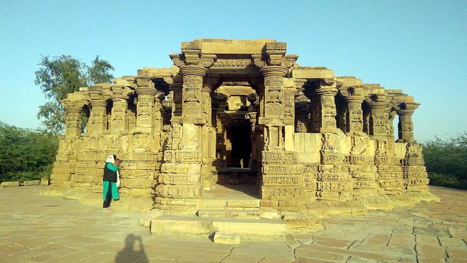
Tourism in Barmer is centered around its historic monuments and temples. The city hosts several temples that attract visitors from across the country, most notably the ancient temple of Goddess Jagdamba. Archaeologists suggest the Jagdambe Mata temple is approximately 500 years old and is situated at a height of around 140 meters above the plain.
Barmer’s annual cattle fair, known as Tilwara, is a major event that draws crowds each year. The fair, along with the region’s camel milk, woollen industries, carved wooden furniture, and handicrafts, contributes to the local economy.
The Thar festival, organized by the government every March, is the major festival of the region. It is held to attract tourists and celebrate the cultural heritage of Barmer district.
Based on: the Wikipedia article (CC BY-SA 4.0) — facts from that source; edited and translated by Times of Rajasthan.
Farm advisory
Sat
35° 21°
0% · 0mm
Sun
35° 23°
0% · 0mm
Mon
35° 22°
0% · 0mm
Tue
34° 21°
0% · 0mm
Weather: Open-Meteo forecast. General advice — ask your Krishi Vigyan Kendra or agriculture supervisor for doses.
 VISUAL STORY · WITH MUSICBarmer Darshan▶ Watch & listen
READERS’ POLL
Vote to see the results
A proverb, a word and a district from the land of dunes — every day
PROVERB OF THE DAY
“पाणी पीजे छाण कर, गुरु कीजे जाण कर”
Strain water before you drink it; know a teacher before you follow one.
MARWARI WORD
मनवार
Lovingly insisting a guest eats and drinks a little more
DISTRICT OF THE DAY
Chittorgarh
FAIRS & FESTIVALS
This month: Pushkar Fair, Bundi Utsav
Kumbhalgarh Festival
Rajsamand · December
Discover Rajasthan →